
Raj Bhagat Palanichamy of WRI India is preparing open source free online tools and maps to deal with floods.
As Bengaluru and Chennai stare into a future which is likely to be dotted with more floods, Raj Bhagat Palanichamy is busy working on a defence strategy. He is preparing an online tool and maps for Chennai and Bengaluru. Raj works as a GIS and remote sensing analyst with WRI Ross Cities program at WRI (World Resources Institute) India. A not-for-profit global research organisation, WRI works on ideas to create sustainable cities.
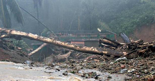
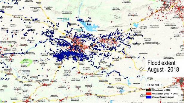
During the recent floods, he had released maps of Kodagu and Kerala that aimed at helping authorities and people involved in rescue work by sharing information. On whether his maps could achieve their objective, the young researcher says, “I got an SOS call from the disaster management wing of the Revenue Department of Karnataka, one morning asking for these maps. I shared with them an interactive website which gave them access to these maps. I think drone surveys were commissioned in Kodagu after consulting our maps. With Kerala, there was no direct channel of communication between us and its government. Also, the authorities in Kerala were right in the thick of action so we couldn’t really interact. The idea was to tell the governments that there are ways to seek information. Social media was interested. My tweets had 40,000 impressions.”
With high possibilities of flooding occurring in Bengaluru and Chennai in the coming months, Raj is now working on maps for both the cities and plans to release it five days before the meteorological department predict heavy downpours. Raj reveals that one can extract more accurate data closer to the date. An hour of observation is needed to generate maps. “Our mandate was never to deal with a crisis on a short-term basis. The 2015 Chennai floods made us realise that there is a need to have a structure for a short-term solution to save lives. We are now working on an open source online tool that will predict the areas to be most affected and also monitor those areas. The online tool will be ready sometime in 2019 as it is stuck right now due to paucity of funds but the maps will be there soon, though.”
Raj feels the conversations should be on handling the climate change. “Like how to diversify our cities so they don’t get overburdened. While the government looks at flooding with an engineering perspective — building and clearing canals, the main thing is rainwater harvesting. We could use parks to hold rainfall and avoid constructions on flood plains.”
He says the flood tool can send out a warning. The findings can be integrated into the planning to identify critical areas and avoid construction there. The tool will help in identifying critical buildings such as hospitals and schools to come up with a proper defence mechanism against floods.
Raj feels too much dependence on dams is not recommended. “Traditional ways of water conservation and improvement of water efficiency and productivity need to be the focus. The government shouldn’t focus on mega projects.” He also feels that the gap between analytics and planning should be bridged. “There are 100 of research projects about the flooding in Mahanadi river but these have not been integrated into planning because researchers probably don’t know how to reach out and publicise their work. The Amaravati floods very often not just because of the infrastructure but also due to lack of planning.”
source: http://www.thehindu.com / The Hindu / Home> Society / by Shailaja Tripathi / September 18th, 2018

